All Photos Are Below the Travelogue Text
Click on Any Photo To Open Slide Show
To print the travelogue, right click anywhere on the page. Choose "Print" from your browser dialog box. You can choose Save to PDF in the browser print window.
Share your thoughts.
Email Dave - coxdavid55@hotmail.com
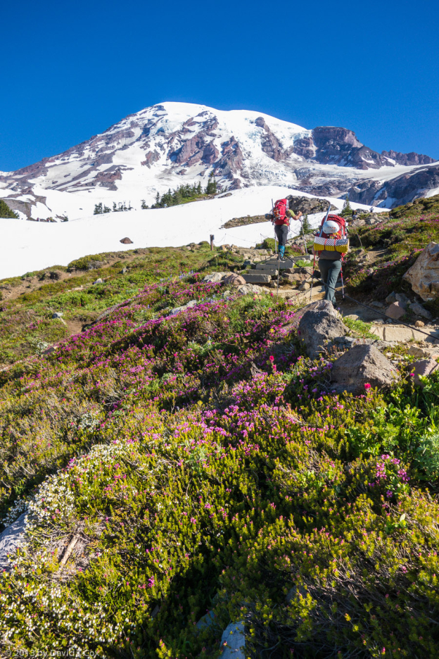
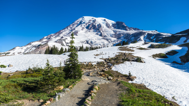
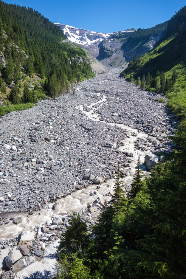
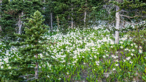
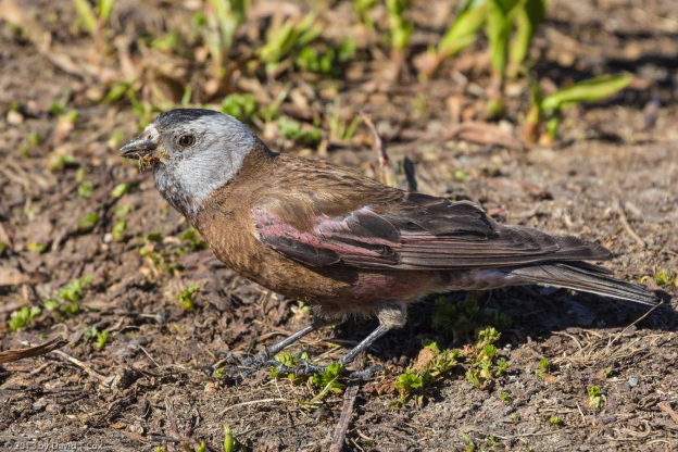
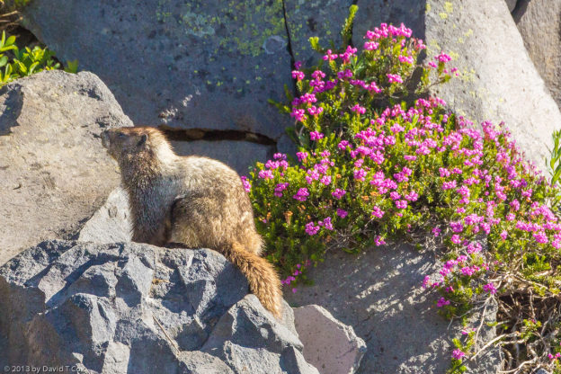
Hello everyone. I last reported from Mt Rainier in Washington, but had not yet visited the Park. Mt Rainier is simply a stunning sight traveling southeast from Tacoma. At well over 14,000 feet and at a high latitude, it’s volcanic peak is covered with glaciers. I spent 5 days, splitting the time at two small camps right at the southwest entrance to the Park. A number of short hikes on various trails occupied much of my time, but the clear highlight was the climb from Paradise, the main visitor center near tree line, up the Skyline Trail; this is the trail which leads eventually up to Muir Base Camp which dozens of climbers use daily to rest before the ascent to the peak. I, of course, did not do the multiday ascent, which requires specialized equipment and guides for the glaciers. I did climb to the lower glacier edges for spectacular views of the mountain. At this level I finally found the Grey-crowned Rosy-Finch and Yellow-Pine Chipmunks, as well as more Hoary Marmots playing in the wildflowers blooming in the snow-melt meadows. Other awesome sights are the glacier fed river channels, which carry huge mud-flows every other year or so, released by internally dammed water in the glaciers; the flows sweep trees and boulders down slope creating huge scars on the mountain side.
From Mt Rainier I drove to the Yakama Nation RV Park just south of Yakima for one evening. There, for the first time in my life, I spent a couple of hours in a large casino; I did not gamble, but had an extraordinary dinner buffet for about $11. I did nicely stuff myself. Although the casino had tables for all the games I have read of or seen in the movies, almost no one was playing poker, roulette, 21 or rolling dice. In truth, about 98% of the people (probably about 600 people) were sitting at video slot machines; it seems to me, if one is going to gamble, slot machines must be the most mindless form. You don’t even get to pull big mechanical arms.
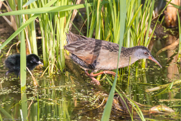
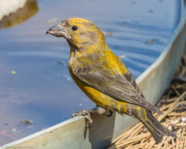
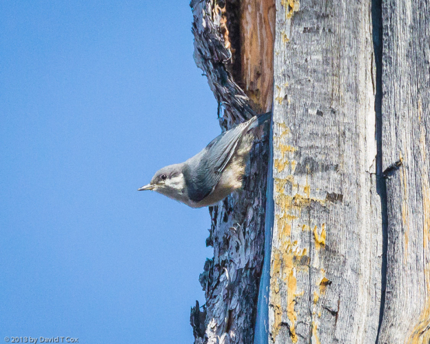
The next day I drove on down to Bend, Oregon. Famed for 12 micro-breweries, many of which distribute bottled beer, I failed to visit any; my excuse was that I knew I couldn’t visit without some serious sampling – and driving in an unknown and twisty town, after brewery fun, seemed unwise. I did, however, buy a couple of six-packs and have enjoyed the beer come evenings. Bend is named for the huge bend in the Deschutes River where the town is sited. The old Lumber Mill on the bend has been converted to parks, walking trails and a large number of popular restaurants and stores. I did birding along the river for two mornings, getting really lucky when a local showed me where to find Virginia Rails with tiny newborns, looking for all the world like hairy black chicken eggs with eyes, beak and legs. I also visited over a period of a couple of days the Newberry National Volcanic Monument just south of Bend. It, along with huge lava flows, a neat cinder cone and lava tubes, had a number of birds in the surround. I finally got to see the very tiny Pygmy Nuthatches, smaller than an Anna’s Hummingbird, flocking at the top of the volcanic cinder cone; obtaining water in the forest around the visitor center were a small flock of the unusual Red Crossbills. I hiked 1 mile inside the “Lava River Cave”, an extremely well preserved lava tube which perhaps continues unbroken for miles further, but is blocked by sand at the far end – the entire distance is utterly black, requiring good lights to navigate; the tube stays at a constant remarkably cold 42 degrees.
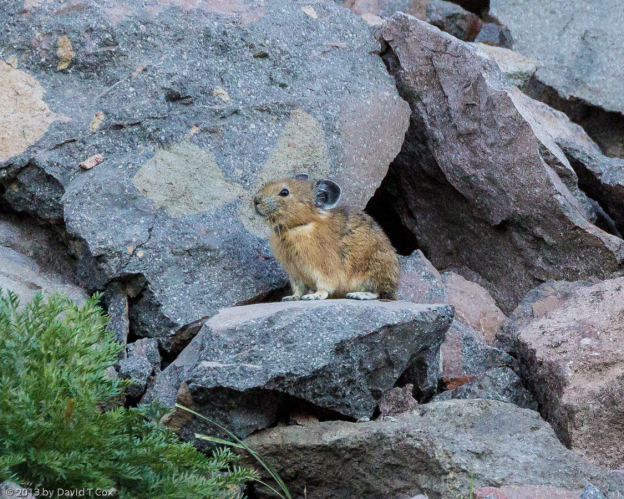
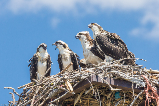
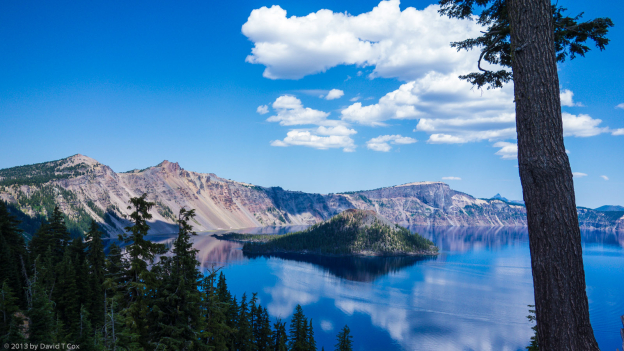
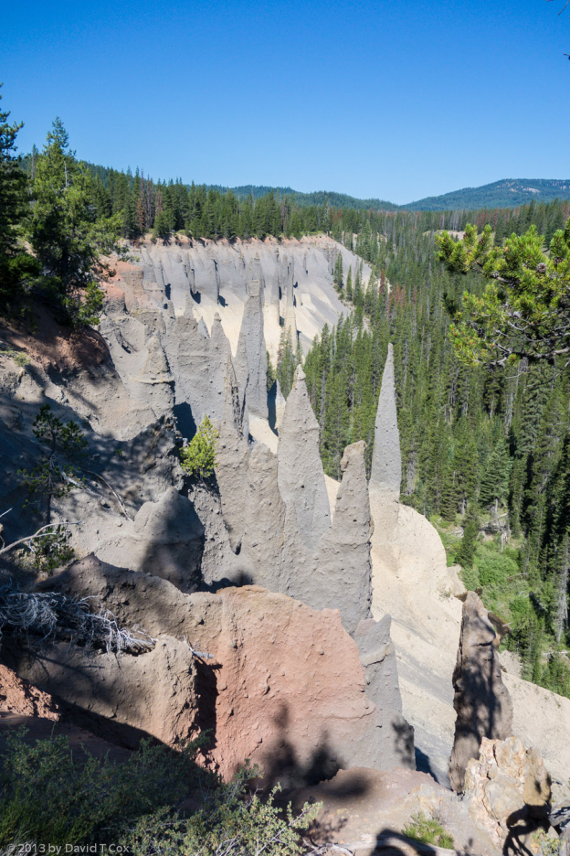
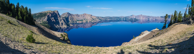
From Bend I traveled on south to Fort Klamath, just a few miles south of Crater Lake National Park. Crater Lake is really a “jaw-dropper” – spectacularly blue, filling a volcanic caldera measuring about 6 miles from rim-to-rim. The lake is the deepest in the United States (close to 2,000 feet), and the claim is it contains the purest water on earth, setting a world record for clarity some years back with over 140 foot visibility. Finally, after more than a dozen hours of specific searching in 6 different National Parks, I found Pika, the small rabbit like rodents which live in talus slopes at tree line. Downslope from the volcanic crater are “fossils” of fumaroles, the gas emitting vents around active volcanic mountains. Here, the super-heated gases had vented terminally through hundreds of feet of spewed volcanic ash, and the heat actually fused the ash into stone tubes around the vents; over millennia the surrounding ash eroded into a river canyon, leaving the most unusual stone spires, hundreds of feet tall, along the cliff edge of the valley (see photo). Below the park, near where I stayed, I found an Osprey nest with three fully grown juveniles along with a parent, all standing in a perfect photo line; I cried “fish” instead of “cheese” for the obligatory photos.
From Fort Klamath I drove into north-central California to the small ex-lumber town of Weed. Although many commercial references to the name are amusing (T-shirts & mugs engraved with “I ‘heart’ Weed”), the town, in fact, was named for Abner Weed, who established the lumber mill in the late 19th century. Located at the base of 14,000 foot, volcanic Mt Shasta, it sports the small Mt Shasta Brewery, which I do intend to visit this evening.
I had thought I would travel until the summer heat breaks in southern Arizona, usually mid September, but I am reconsidering. I have grown a little weary of the journey as I have traveled south through Washington and Oregon. It will be 90 days this week since I set out from Tucson, and over the last 12 years I have found 3 months to be the optimum travel time for me; it has little to do with returning “home,” but rather to do with the fatigue of travel itself. I was looking forward to the prospect of visiting the great National Parks of California (Yosemite, Kings Canyon & Sequoia), but my current research indicates the next 4 weeks to be the absolute height of tourist season, and the worst possible time to try to visit those parks for interests in nature. Also, the weather has been so unseasonably hot since my last days in Montana, almost 4 weeks ago, coupled with my current location in the mid-latitude deserts, that I see little advantage to avoiding Tucson heat just from a weather perspective. I am contemplating postponing the California Park’s visit until a better season, and traveling instead across the “Loneliest Road in America,” Hwy 50 through Nevada, into Utah and back south then to Arizona. I will stay here a few days deciding what to do.
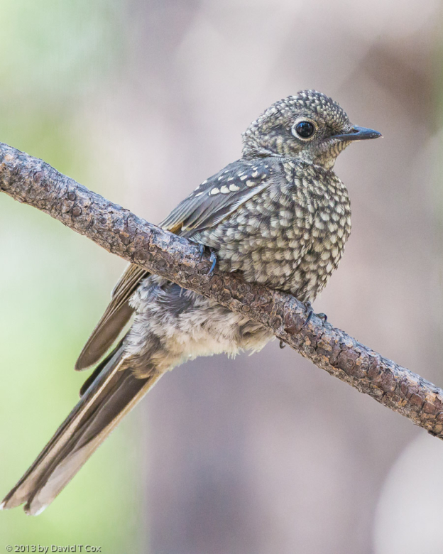
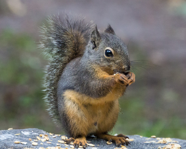
I have included photos of Mt Rainier with some Alpine flowers and Nisqualy glacial mud-flow Canyon, Crater Lake and fossil fumaroles, plus hoary marmot, grey-crowned rosy finch, Douglas squirrel, juvenile Townsend’s solitaire, female red crossbill, Virginia rail with chick, 4 ospreys at nest and pika. Later, Dave
To print the travelogue, right click anywhere on the page. Choose "Print" from your browser dialog box. You can choose Save to PDF in the browser print window.
Share your thoughts.
Email Dave - coxdavid55@hotmail.com